Author: Flora Weissgerber

  • Measurement of the height of the Eiffel Tower with interferometry

    SAR sensors are echo-localization systems. They measure the time between the emission of an electromagnetic pulse and its reception after that it have been backscattered by targets. This time is firstly converted in distance and then in pixels. The coordinates of a target in the image correspond to the number of resolution cells included in the distance: it is an integer. But the SAR signal keep in memory the sub pixel length of the path between the emission and the reception. One way this memory is kept is through the phase of the pixel. Indeed, the pixels of SAR images are complex numbers.

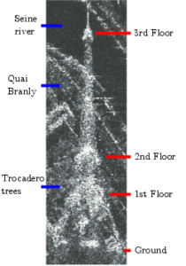
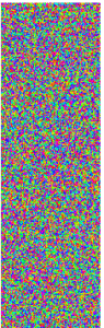
    The SAR images are often represented in amplitude only because the information conveyed in the amplitude is the most easily interpretable: the amplitude of the pixels represents the energy of the backscattered signal. A metallic structure as the Eiffel Tower will backscatter most of the emitted pulse and thus be very bright in the image. On the contrary, the Seine river does not scatter signal back to the satellite. It is thus dark in the image. On the other hand, the phase of a unique image is completely random.
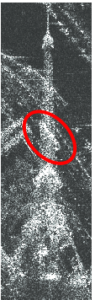
    TourEiffel_legendimage_bruit_phase
    Amplitude image of the Eiffel Tower and its phase

    The magic happens when the phase of at least two images are compared. The phase difference that is computed can bring information of the height of the targets if the images are acquired from slightly different location. This technique is called interferometry. The phase difference can also bring information on the deformation of the target between the acquisition if the images are acquired at different time. This technique is called differential interferometry. When the images are acquired from slightly different location and at different time, both height and deformation are mixed in the phase difference. The proportion of the mixing depends on the acquisition condition.

    When it comes to buildings, deformations are often neglected: the height of the buildings is considered as proportional to the phase difference. Since the phase is 2π-periodic, the height can only be estimated modulo the ambiguity height. The ambiguity height is determined by the acquisition parameters. For example, it is inversely proportional to the distance between the two satellites but proportional to the satellites’ altitude or the wavelength of the pulse. To estimate to absolute height, the phase need first to be unwrapped.

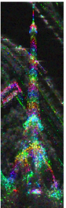
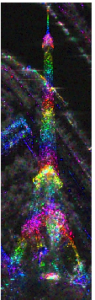
    The images below are 2 interferograms between TerraSAR-X Spotlight images (thanks to the DLR projet LAN2708). The unwrapping of the phase can be done roughly by counting the fringes: the color legend is 2π-periodic, each color rainbow represents a fringe. We count approximately  6.5 fringes on the image on the left. With an ambiguity height about 46 meters, the measured height is 278, close to the 320m official height of the Eiffel Tower and its antennas.  On the image on the right, 4 fringes can be counted. But ambiguity height is now of 412 meters leading to a 1600m Eiffel Tower.  This surprising result is caused by the non-deformation hypothesis. Indeed, the Eiffel Tower is moving of few centimeters between the acquisitions, mostly due to thermal effects and this deformation impact the phase.
    interfero_hamb_46 interfero_hamb_-412
    Left : ambiguity height of 46m , Right ambiguity height of 412m

    -πcolorbar_hsv_allonge_red π
  • The Eiffel Tower in SAR imagery

    The Eiffel Tower is an emblematic monument in Paris. I have studied it through a temporal stack of 100 images acquired by TerraSAR-X in spotlight mode (thanks to the DLR projet LAN2708). See how it looks in SAR imagery. The image has a 1m x 1m resolution: one pixel represents roughly a 1m x 1m ground area. This means that targets that are separated by 1m in the scene will be separated in the image.

    To make an image, the SAR sensor emits pulses of electromagnetic waves and record the backscattered signal. On the contrary to most optical satellite, the SAR sensor has an oblic view making the side of the Eiffel Tower visible. We can thus see the different parts of the structure of the Eiffel Tower, as well as some buildings, the Seine river and the Trocadero. As in optic, some objects can block the wave, creating shadow behind them. I have cut the shadow of the Eiffel Tower, but the shadow of nearby buildings is visible.

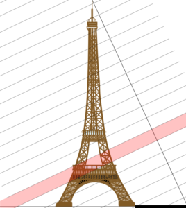
    This image is a good illustration of the layover effect. Since SAR sensor is an echo-localisation technique, the treatment that creates the image, the synthesis, is based on the measure of the distance between objects as the Eiffel Tower and the satellite. Thus all the objects that are at the same distance to the satellite will be in the same pixel.  The 3rd floor of the Eiffel Tower and the Seine river appear in the same pixels as well as the 2nd floor and the trees of the Trocadero.

    The synthesis is based on the assumption that all the object in the scene are static. When objects are moving during the acquisition, they can be defocalized or delocalized depending on the direction of their mouvement. A peniche boat that was moving on the Seine river is thus delocalized on the quai Branly.

    TourEiffel_legendSAR_Geometrieimage_peniche_anot

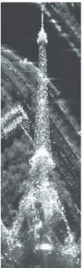
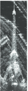
    Due to the interaction of the emited wave with rough objects, speckle is present in SAR images. Speckle looks like a salt and pepper noise on homogeneous areas. Its effect can be removed by averaging pixels through the temporal stack. The average can be quadratic (left) or  geometrical (right). The two averages look mainly alike, even if the contrast is sharper on the quadratic mean. Some differences appear on the Seine river. They are due to changes in few images of the temporal stack: mostly peniche boats that are present only in one date. These changes are erased by the geometrical mean but still impact the quadratic mean.

    moyenne_geomoyenne_ari
  • DInSAR on the Eiffel Tower for the Gretsi 2015 in Lyon

    SAR Interferometry (InSAR) and SAR Differential Interferometry (DInSAR) are two well-known techniques of Synthetic Aperture Radar (SAR) image processing. SAR Interferometry measures the phase difference between 2 images acquired from slightly different points of view to obtain the height of the scatterers. Interferometry is often multi-pass: the two images are acquired by the same sensor at different time. But it can be mono-pass if the two images are acquired at the same time,  such as TerraSAR-X and TanDEM-X conjoint acquisitions. SAR Differential Interferometry is always multi-pass: this technique permits to retrieve the movement of the scatterers between the date of acquisition from the phase difference between 2 images acquired from the same point of view.

    In this article, we show that the height retrieval from multi-pass acquisition over target which shape changes can give tricky results. We carry out this study on a temporal serie of 10 SAR images acquired by TerraSAR-X in 2009 and we focus on the measure of the height of the Eiffel Tower since it is normally a target with a well-known height!

    After unwrapping the phase on the Eiffel Tower, we compute its height throught interferometry. The measured height could exceed 1km! We credit this error to the mixture of the interferometric phase with the phase due to the displacement of the scatterers in time: DInSAR is needed.

    To supress the interferometric component, we used the official height of the Eiffel Tower as a DEM.  We found dilatation up to 4cm. Depending on the baseline, this deformation could lead to the kilometric error on the interferometric height. If a deformation model was available, it would be possible to compute the deformation conjointly with the height. Studies on the deformation of buildings make often the assumption that the variation of height is linear and estimate only a deformation velocity. This is not possible for the Eiffel Tower because its deformation depends heavily on the weather (temperature, wind and the amount of sunshine per day). It is not regular in time. Complementary information on the deformation of structure and the weather at the time of acquisition are thus needed to validate to estimate conjointly the height of the first acquisition and the deformation.


  • In a week of Multitemp 2015, in Annecy

    My presentation will focus on the comparison between spatially estimated polarimetric entropy and temporally estimated polarimetric entropy. Indeed, long term temporal series become accessible for SAR images in full-polarimetric mode, thanks to the new lauches of satellites and to the wider distribution of SAR images by spatial agencies. It allows to monitor the evolution of scattering mechanism in time and to use different tools to characterize the scene.

    Polarimetric entropy is a classical tool for PolSAR images study and classification. It is often used as an indicator of the variability of scattering mechanisms for given homogeneous areas. In order to estimate entropy, the covariance matrix has to be estimated. This is mostly done using the sample covariance matrix estimator on adjacent pixels. Thus, the entropy becomes an indicator of the variability of scattering mechanisms present in the sample set used for its estimation.

    Using a temporal series, new estimation methods of entropy can be employed. For example, entropy can be estimated using the temporal samples of the same pixel. This temporal entropy gives us information about the temporal stability of the scattering mechanisms. New classes of scatterers seem to emerge in natural areas. In urban areas, the contrast of entropy between streets, parks and buidlings is less dependent on the street orientation with temporal entropy than with the classical spatial entropy.

    These results on entropy estimation open new perspectives for an Entropy/alpha classification scheme combining spatial and temporal entropy.

  • Paper accepted as an oral presentation at POLinSAR 2015

    The paper deals with the enhancement of the resolution of polarimetric SAR imagery.

    Due to technical constraints on the system design, the azimuth resolution is coarser in polarimetric images than in the mono-channel acquisition of the same SAR sensor. We aim at enhancing the resolution of polarimetric images using a high resolution image. The idea is close to the concept of pansharpening in optic image processing. But unlike optic pansharpening which is used to improve the visual quality of images, we want to preserve the polarimetric behavior of the scatterers in the image so that the resulting image remains useable for classification purpose.

    The speckle phenomenon makes the concept of resolution unclear in homogeneous areas. For bright points or point-like scatterers, improving the resolution means decreasing the width of the main lobe of the PSF. This can be achieved by expanding the spectrum of the original image. The location of the SAR spectrum in the Fourier space is directly linked to acquisition parameters: the angular aperture and the bandwidth. Based on the hypothesis of isotropic and white targets we can use the polarimetric behavior of the low resolution image to expand the spectrum while keeping the initial polarimetric behavior.

    Post conference note:
    My presentation entitled Spectral method for bright scatterers resolution enhancement can be accessed on the POLinSAR 2015 website.